Big Valentines Day Snow Storm Forecast For Parts Of South Dakota
Your South Dakota Valentine's Day could be impacted by a quick-moving snowstorm bringing up to 9 inches of snow in parts of the state.
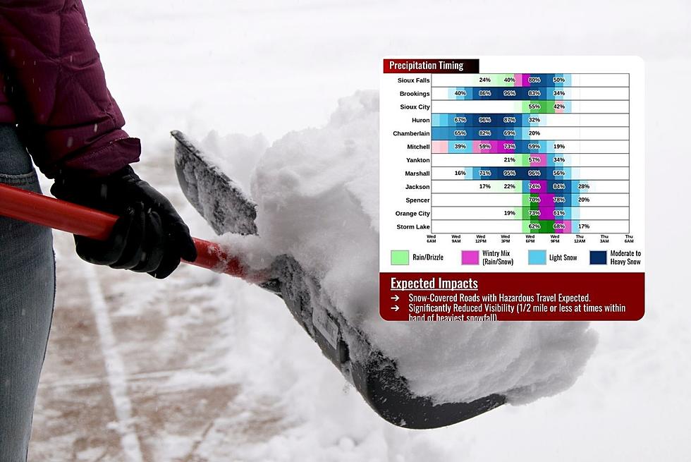
From the National Weather Service In Sioux Falls...A quick-moving band of moderate to heavy snow is expected north of I-90 today through midnight tonight.
Rapid snow accumulation during the late morning and afternoon will lead to a narrow corridor of heavier snow amounts in excess of 6 inches, with localized amounts topping 8 inches possible.
Be prepared for significantly reduced visibility and snow-covered roads for the evening commute.
...WINTER STORM WARNING IN EFFECT FROM 8 AM THIS MORNING TO 9 PM
CST THIS EVENING...
* WHAT...Heavy snow expected. Total snow accumulations of 4 to 8
inches.
* WHERE...Beadle, Kingsbury, Brookings, Jerauld and Sanborn
Counties.
* WHEN...From 8 AM this morning to 9 PM CST this evening.
* IMPACTS...Travel could be very difficult due to low visibility
and snow-covered roads. The hazardous conditions could impact
the evening commute.
* ADDITIONAL DETAILS...Snow may rapidly accumulate during the late
morning and afternoon, with visibility reduced to a half mile or
less at times.
Never Buy These 10 Items At Minnesota, Iowa, Or South Dakota Dollar Stores
Gallery Credit: Getty Thinkstock
More From KYBB-FM / B102.7